REPORT ON AQUIFER MAPPING AND MANAGEMENT PLAN IN SIWAN DISTRICT, BIHAR (AAP 2022-23)
| Category |
Aquifer Mapping |
| State |
Bihar
|
| District |
Siwan |
| Block |
Andar Barharia Basantpur Bhagwanpur Hat Darauli Daraundha Goriakothi Guthani Hasan Pura Hussainganj Lakri Nabiganj Maharajganj Mairwa Nautan Pachrukhi Raghunathpur Siswan Siwan Ziradei |
| Year of Issue |
2023 |
| Number of Authors |
3 |
| Name of Authors |
Siperna Nayak, Assistant Hydrogeologist,Ms. Manashi Bhattacharyya, Scientist-B ,Shri Anurag Shukla, STA (Chemical) |
| Keywords |
Climate and Rainfall Hydrogeological Studies Geophysical studies MANAGEMENT STRATEGIES Conceptualization of aquifer system in 3D |
| File |
Download |
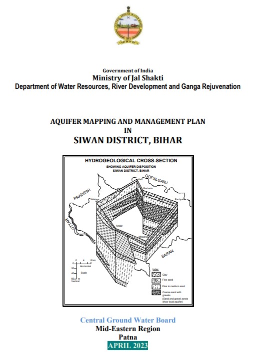
The study area lies in the Indo-Gangetic Plains of Bihar and forms the western part of the state
(Fig.1). It covers a mappable area of 2223 sq.kms. and consists of 19 blocks namely, Andar,
Barharia, Basantpur, Bhagwanpur Hat, Darauli, Daraundha, Goriakothi, Guthani, Hasanpura,
Hussainganj, LakriNabibganj, Maharajganj, Mairwa, Nautan, Pachrukhi, Raghunathpur, Siswan,
Siwan, Ziradei. The study area geographically lies between 25.58o N to 26.23o N latitude and
84.10o E to 84.47o E longitude. The area is covered in Survey of India toposheet nos.
72B/11,72B/12, 72B/16, 72B/4, 72B/7, 72B/8, 72C/1, 72C/5. It is bounded in the North by
Gopalganj district, on the east by Saran district and on the west and south by two districts of
U.P. viz. Deoria and Balia respectively