Main Links
AQUIFER MAPPING & MANAGEMENT
Water is elixir of life and all developmental activities enhance the demand of water, whether it is agriculture or industry. The ever increasing population also results in the increase in domestic demand. The water resources are available either as surface water or groundwater and the principal source for both the resources is precipitation. The erratic nature of precipitation and near utilization of surface water resources has turned the onus on groundwater. The groundwater occurrence and movement varies spatially and temporally and it is also not uniform. Thus, the strategy for sustainable development and management becomes a challenging task.
Growing water scarcity is being recognized as an important problem facing India. Groundwater is an important natural resource to meet the water requirements of our country. Groundwater irrigation has been expanding at a very rapid pace in India since 1970s and now accounts for over 60 percent of the total area irrigated in the country. About 85% of the rural drinking water supply is also met from ground water sources. The most significant change in the groundwater scenario in India is that the share of bore well irrigation went up from a mere 1 percent during 1960-61 to 60 percent during 2006-07 as per Indian Agricultural Statistic, 2008. The estimated number of wells and bore wells in India is now around twenty-seven million, with bore wells accounting for more than 50 percent. There is a steady increase in the share of groundwater in irrigation over every decade. Thus a need was felt for scientific management of groundwater resources and the need has turned to urgency in the present times. There has been a paradigm shift from groundwater development to groundwater management over the last decade. The importance of groundwater for national development has deemed it necessary to be more specific; more general “groundwater management” has become “aquifer management” to answer the specific queries on availability and sustainability. CGWB has taken up National Project on Aquifer Management in XII & XIII Plan period to formulate sustainable aquifer management plan.
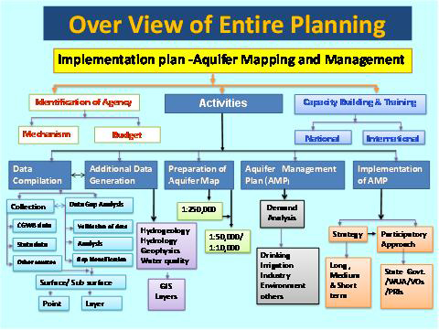
The flow chart for the execution of work is represented as a flow chart

The entire gamut of activities has been grouped under five activities as given below along with the tentative time lines.
S.No |
Activity |
Year 1 |
Year 2 |
Year 3 |
Year 4 |
Year 5 |
1 |
Compilation of Existing Data, Principal Aquifer Delineation & Data Gap Identification |
|
|
|
|
|
2 |
Generation of Data |
|
|
|
|
|
3 |
Aquifer Map Preparation( 1: 50,000 scale and For identified areas in 1:10,000 scale) |
|
|
|
|
|
4 |
Aquifer Response Model/Aquifer Management Plan |
|
|
|
|
|
5 |
IEC Activity & Implementation of Aquifer Management Plan |
|
|
|
|
|
- Concept Paper
- Priority Areas for Aquifer Mapping
- Seminar on National Project on Aquifer Management
- Draft Manual on Aquifer Mapping
- Process Flow and SOPs
- Aquifer Mapping Reports - Pilot Areas