Groundwater has been the prime source of fresh water sustaining life and livelihood in India. The share of groundwater in irrigation has increased from 61% in 2007-08 to 64% in 2016-17 as per the data of Directorate of Economics & Statistics Ministry of Agriculture & Farmers Welfare. Ground water still accounts for the major share (94.8%) of all the minor irrigation schemes in the country. At the National level, among ground water schemes, dug well and shallow tube/bore well are declining whereas an increase has been observed in medium and deep tube/bore well (Source: 6th Census of Minor Irrigation Schemes Report). Dependence on ground water is increasing day by day as groundwater accounts for most of the increase in net irrigated area in the country. This hasn’t come without a price. As per the latest assessment of Dynamic Ground Water Resources (2023), out of the total 6553 assessment units (Blocks/ Taluks/ Mandals/ Districts/Firkas/Valleys), 736 (11.2%) have been categorized as ‘Over-exploited’, 199 (3%) as ‘Critical’, 698 (10.7%) as ‘Semi-critical’ and 127 (1.9%) are 'Saline’. Alongside over-exploitation there are also areas where existing groundwater resources have not been tapped properly. Further, there are well documented issues of ground water contamination also. Climate change is likely to bring in more challenges in terms of decreasing availability, increasing demand for irrigation (because of increase in atmospheric temperature) and increase in coastal salinity (because of rise in sea level). Govt. of India, State Governments and many other agencies are doing their best to augment and manage ground water resources. However, understanding of the aquifers is the first prerequisite to prepare effective management interventions. The report of the Working Group (constituted by the erstwhile Planning Commission) for the XII plan on ‘Sustainable Ground Water Management’ highlighted the need for comprehensive mapping of India’s aquifers, on priority, that would form the cornerstone of developing any groundwater management programme. In this backdrop, Central Ground Water Board (CGWB), under the Ground Water Management and Regulation Plan Scheme (XII plan) initiated the National Aquifer Mapping and Management (NAQUIM) programme in the year 2012, which is one of the largest endeavours of its kind in the World.
With an aim to support effective management of ground water resources in the country, the NAQUIM programme was taken up with the following objectives:
- Delineation of aquifers in terms of their horizontal and vertical extent.
- Characterization of aquifers in terms of their hydrogeological properties
- Resource availability and quality
- Preparation of aquifer maps
- Identification and quantification of issues
- Developing management strategies to ensure sustainability of ground water resources
| English | Hindi | Tamil |
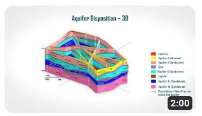
A multidisciplinary approach including geological, geophysical, hydrogeological, hydrological and water quality studies is being followed for preparation of aquifer maps and management plans. Four major sets of activities being undertaken for the purpose are: (i) data compilation & data gap analysis (ii) Generation and integration of data (iii) Preparation of aquifer maps and (iv) Formulation of aquifer management plans. Data available in the domain of ground water is collected from various sources. The data are screened so that they can be used as per the objective of the study. On the basis of that, the gap in availability of data is estimated. Various type of data are generated on the type of aquifers, their physical properties, geophysical properties, hydraulic properties, chemical quality etc. Then the useful data from existing sources and data generated are integrated for further processing. The physical dimensions of aquifers are delineated. The water level behaviour, ground water resource availability, well sustainability, chemical quality, inter-aquifer interaction, yield of the aquifer etc. are ascertained. To start with, 6 pilot studies were taken up in 5 different States (Maharashtra, Rajasthan, Bihar, Karnataka, Tamil Nadu) in representative hydrogeological terrains of the country. The learning from the Pilot projects have been synthesized and adopted in nationwide Aquifer Mapping and Management programme Aquifer maps and management plans developed under this programme are backed by rigorous field surveys by the professional hydrogeologists of CGWB in different regional offices. Aquifer maps and management plans, thus prepared are subject to a three-tier review including review by a National Level Expert Committee (NLEC) before finalization. The NLEC comprises domain experts from CGWB; IIT Roorkee; IIT Delhi; JNU and IWMI. CGWB has been working in coordination with its state government counterparts. CGWB has also collaborated with organizations/institutes like GSI, NGRI, IMD, NRSC, IISc, IIT etc. on specific topics to ensure adoption of modern tools and techniques.
CGWB has carried out Pilot Projects on Aquifer Mapping in Six different Hydrogeological terrains since 2013 covering parts of states in Bihar (Alluvial plains of Ganga basin in Watershed GNDK013, Patna District), Rajasthan (Alluvium overlying hard rocks in Baswa-Bandikui, Dausa District and Parts of Thar Desert Terrain in Jaisalmer district), Maharashtra (Basaltic traps underlain by Gondwanas in Watershed WGKKC-2, Nagpur District), Karnataka (Crystalline rocks in Parts of Tumkur District) and Tamil Nadu ( Coastal sediments in Lower Vellar Watershed, Cuddalore District, Tamil Nadu). The objectives of the pilot studies were to define the aquifer geometry, types of aquifers, ground water regime behaviours, hydraulic characteristics and geochemistry of Multi-layered aquifer systems on 1:50,000 scale, application of new geophysical techniques and establishing the utility, efficacy and suitability of these techniques in different hydrogeological setup and thus finalizing the approach and methodology on which National Aquifer mapping programme of the entire country could be implemented. The experiences thus gained could be utilized to upscale the activities to prepare micro level aquifer mapping in the future.
| Pilot Aquifer Mapping Study Area | Report |
|---|---|
| Cuddalore, Tamil Nadu | Click to Download |
| Nagpur, Maharashtra | Click to Download |
| Dausa, Rajasthan | Click to Download |
| Jaisalmer, Rajasthan | Click to Download |
| Patna, Bihar | Click to Download |
| Tumkur, Karnataka | Click to Download |
Out of the total geographical area of nearly 33 lakh km2 of the entire country, an area of about 25 lakh km2 mappable area has been identified for coverage under NAQUIM programme. Mapping of entire targeted area has been completed in the year 2023.The studies completed so far have provided several newer insights into ground water scenarios and management alternatives. Evidence based management interventions including supply and demand-side measures are recommended for containing over-exploitation in stressed aquifers. Alternative contaminant-safe aquifers have been delineated in many areas, where ground water contaminations have been reported. The studies show that large aquifer systems can be recharged in an integrated manner improving ground water availability for irrigation over extensive areas. While recharge augmentations have so far been the major tool of ground water management in the country, NAQUIM studies have brought out that demand- side management has more pronounced effect on improving ground water scenario in comparison to supply side interventions. NAQUIM studies also lead to framing strategies to promote ground water utilization to source irrigation in the areas which are irrigation deprived and where adequate scope for further development of groundwater exists.
A multi-tiered approach has been adopted for sharing of NAQUIM outputs. Secretary (WR, RD & GR) has written DO to all the Chief Secretaries, various Central Ministries to make best use of the NAQUIM outputs. State Ground Water Coordination Committees (SGWCC) have been constituted at State Level. SGWCC are headed by the Principal Secretaries of the concerned departments of the respective States. In 2018, CGWB initiated sharing of NAQUIM outputs with the District Authorities (DM/DC). Outputs in respect of 496 districts shared with respective DM/DC. Public Interaction Programme (PIP) at grassroots Level Initiated in 2018. 1300 PIPs conducted so far in which nearly 1 lakh persons participated. Findings of NAQUIM studies are disseminated through the website of www.cgwb.gov.in & www.aims-cgwb.org. Data are also disseminated through India Water Resource Information System (India-WRIS). The reports can also be accessed through the link "Aquifer Mapping Reports" under the "Quick Links" menu. The findings of NAQUIM studies are being utilized by many agencies especially the State government agencies involved in ground water management and water supply. Major areas where NAQUIM outputs have been used include
- Drinking water source finding and source sustainability Site selection for Artificial Recharge Safe drinking water in Arsenic affected areas Assured irrigation through ground water in areas that have adequate ground water potential. Implementation of water conservation and AR recommendations Ground Water Regulation based on NAQUIM recommendation Rejuvenation of springs Atal Bhujal Yojana
Building on the experience of the NAQUIM, CGWB has initiated the NAQUIM 2.0 activities with the following broad objectives Providing information in higher granularity with a focus on increasing density of dynamic data like ground water level, ground water quality etc. Providing issue based scientific inputs for ground water management up to panchayat level Putting in place a strategy to ensure implementation of the recommended strategies. Major priority areas identified for detailed studies under NAQUIM 2.0 include i) Water Stressed Areas ii) Coastal Areas iii) Urban Agglomerates iv) Springsheds v) Industrial/Mining Areas v) Command Areas vi) Deep-seated Aquifers vii) Auto-flow Areas viii) Poor Ground Water Quality Areas etc. Considering that the deliverables will be different for different priority areas, it is planned to develop priority area specific outputs. Further, it is planned to design the outputs and the knowledge products depending on specific requirements of the user group.